Wellington, New Zealand
| Wellington | |
| — Main urban area — | |
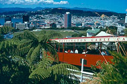
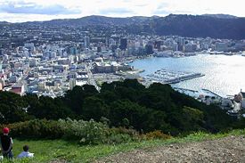
| Wellington Panoram | |
| Nickname: Harbour City, Wellywood | |
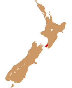
| Wellington urban area within New Zealand | |
| Coordinates: 41°17′S 174°47′E | |
|---|---|
| Country | |
| Region | Wellington |
| Territorial authorities | Wellington City Lower Hutt (administered by Hutt City Council) Upper Hutt City Porirua City |
| Area [1] | |
| - Urban | 444 km² (171.4 sq mi) |
| - Metro | 1,390 km² (536.7 sq mi) |
| Lowest elevation | 0 m (0 ft) |
| Population (June 2011 estimate)[2][3] | |
| - Urban | 393,400 |
| - Urban Density | 886/km² (2,294.8/sq mi) |
| Time zone | NZST (UTC+12) |
| - Summer (DST) | NZDT (UTC+13) |
| Postcode(s) | 6000 group, and 5000 and 5300 series |
| Area code(s) | 04 |
| Local iwi | Ngāti Toa Rangatira, Ngāti Raukawa, Te Āti Awa |
| Website: http://www.wellingtonnz.com/ | |
Wellington is the capital of New Zealand, the country's second largest urban area and the most populous national capital in Oceania. It is in the Wellington region at the southern tip of the North Island, near the geographic center of the country.
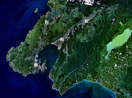
Like many cities, Wellington's urban area extends well beyond the boundaries of a single local authority. Greater Wellington or the Wellington Region includes the entire urban area, plus the rural parts of the cities and the Kapiti Coast, and across the Rimutaka Range to the Wairarapa (the south-eastern corner of the North Island, east Wellington and south-west of the Hawke's Bay region).
Nearly all Wellington residents are within 2 miles (3 kilometers) of the coast. This cosmopolitan city exists in close proximity to nature. Its geography has created a compact city, nestled between harbor and forested hills. The city and its surrounds are replete with wildlife sanctuaries, islands, seaside villages, ocean beaches and regional parks.
Name
Wellington was named in honor of Arthur Wellesley, the first Duke of Wellington and victor of the Battle of Waterloo. The Duke's title comes from the town of Wellington in the English county of Somerset.
In Māori, Wellington goes by two names. Te Whanganui-a-Tara refers to Wellington Harbour and means "the great harbor of Tara." Te Upoko-o-te-Ika-a-Māui, meaning The Head of the Fish of Māui (often shortened to Te Upoko-o-te-Ika), is a more traditional name, derived from the legend in which the North Island was fished up by the demigod Māui Tikitiki-a-Taranga. [4]
History
Maori History and Legend
Maori legend recounts that the great Polynesian explorer Kupe discovered and explored the district in about the tenth century. Maori mythology credits Maui with fishing up a large fish known today as the North Island of New Zealand or Te Ika a Maui and his canoe (waka) or Te Waka a Maui was the South Island. To the Maori, the head of the fish is the sweetest part. Several other Wellington region geographical features make up other parts of the Maui's "fish" including, Wellington Harbour and Lake Wairarapa (the eyes), Palliser Bay (the mouth), Cape Palliser and Turakirae Head (the jaws) and The Rimutaka, Tararua and Ruahine mountains (the spine).[4]
Tara and Tautoki, the two sons of Whatonga, the next Polynesian credited with visiting the region, settled the lower half of the North Island and the top of the South Island. Their descendants include the tribes of Ngai Tara, Rangitaane, Muaupoko, Ngati Apa, and Ngati Ira. Many of the prominent landmarks of the region bear Tara's name including Wellington Harbour's name - Te Whanganui a Tara or the great Harbour of Tara and The Tararua Mountains that divide the Wellington Region from east to west.[4]
Tara’s descendants, the Ngāi Tara people, were joined by the Ngāti Ira tribe from Hawke’s Bay around the seventeenth century. Other tribes including Rangitāne, Ngāti Kahungunu, Ngāti Mamoe and Ngāi Tahu also occupied parts of the Wellington region.[5]
During 1819–1820 the chief Te Rauparaha of Ngāti Toa and a war party, swept south through the North Island, besieging villages and killing the local tribes with muskets. After reaching the shores of Cook Strait he persuaded his people to migrate to the region. During the mid-1820s, tension between these tribes caused the Te Āti Awa, Ngāti Tama and Ngāti Mutunga tribes to move south, and became Wellington’s people of the land.[5]
European settlement
European settlement began with the arrival of an advance party of the New Zealand Company on the ship Tory, on September 20, 1839, followed by 150 settlers on the Aurora on January 22, 1840. The city was named Wellington in honor of the Duke of Wellington who lent his support to the New Zealand Company and the expedition leader Sir William Wakefield. Wakefield is reported as having purchased Wellington from the Maori people for 100 muskets, 100 blankets, 60 red nightcaps, a dozen umbrellas and other various goods.[6] After the Treaty of Waitangi was signed on February 6, 1840, the New Zealand Company was barred from negotiating further land sales.[5]
In 1840 Governor William Hobson chose Auckland as the capital of New Zealand, dashing Wakefield's hope to make Wellington the capital. He also began reviewing the land purchases by the New Zealand Company. In November 1863, the Premier Alfred Domett moved a resolution before Parliament (in Auckland) that "… it has become necessary that the seat of government … should be transferred to some suitable locality in Cook Strait." Apparently there was concern that the southern regions, where the gold fields were located, would form a separate colony. Commissioners from Australia selected Wellington because of its central location and harbor. In 1865, Wellington became the capital of New Zealand, replacing Auckland. Parliament officially sat in Wellington for the first time on July 26, 1865. During the last half of the nineteenth century Wellington grew rapidly from 7,460 residents in 1867 to 49,344 by the end of the century.[5]
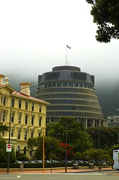
In spite of natural hazards such as earthquakes, fires and the ever-present gale force winds, the fledgling colony of the mid-1800s quickly became a thriving import and export center. The Old Government Buildings were built in the 1870s and is the largest wooden structure in the Southern Hemisphere. The Parliament Buildings, built in 1922, with its square marble angles contrast dramatically with the rounded contours of the Beehive, the capital's distinctive circular Cabinet offices, built in the late 1970s.[6]
Geography
Wellington stands at the south-western tip of the North Island on Cook Strait, the passage that separates the North and South Islands. On a clear day the snowcapped Kaikoura Ranges are visible to the south across the strait. To the north stretch the golden beaches of the Kapiti Coast. On the east the Rimutaka Range divides Wellington from the broad plains of the Wairarapa, a wine region of national acclaim.
Wellington is the southernmost national capital city in the world, with a latitude of 41° 17' South and a Longtitude of 174° 46' East. It is more densely populated than most other settlements in New Zealand, due to the small amount of building space available between the harbor and the surrounding hills. Wellington has very few suitable areas in which to expand and this has resulted in the development of the surrounding cities in the greater urban area.
Wellington has a reputation for its picturesque natural harbor and green hillsides adorned with tiered suburbs of colonial villas. The central business district is sited close to Lambton Harbor, an arm of Wellington Harbour. Wellington Harbour lies along an active geological fault, which is clearly evident on its straight western coast. The land to the west of this rises abruptly, meaning that many of Wellington's suburbs sit high above the center of the city.
In the east is the Miramar Peninsula, connected to the rest of the city by a low-lying isthmus at Rongotai, the site of Wellington International Airport. The narrow entrance to Wellington is directly to the east of the Miramar Peninsula, and contains the dangerous shallows of Barrett Reef, where many ships have been [[shipwreck|wrecked\\ (most famously the inter-island ferry Wahine in 1968).
Wellington Harbour has three islands: Matiu/Somes Island, Makaro/Ward Island and Mokopuna. Only Matiu/Somes Island is large enough for settlement. It has been used as a quarantine station for people and animals and as an internment camp during the First and Second World Wars. It is now a conservation island, providing refuge for endangered species including the kiwis.[7], much like Kapiti Island further up the coast.
The southern section of the North Island’s longest active fault, the Wellington–Mōhaka Fault, passes through the heart of Wellington. Over 75 percent of people in the Wellington region live within 6 miles (10 kilometers) of the fault. Wellington's distinctive landscape is a result of activity on this fault. The sea has flooded into the fault depression near the coast creating Wellington Harbour. During earthquakes along the fault, areas of land south-east of the fault subside, while land along the north-western side moves upward.[8]
Earthquakes
Wellington suffered serious damage in a series of earthquakes in 1848 and from another earthquake in 1855. The 1855 Wairarapa earthquake occurred on a fault line to the north and east of Wellington. It ranks as probably the most powerful earthquake in recorded New Zealand history, with an estimated magnitude of at least 8.2 on the Richter scale.[9] An estimated 1930 sq. miles (5000 sq. kilometers) of land shifted vertically, with an estimated uplift of 20 feet (6 meters) near Turakirae Head and 3-6 feet (1-2 meters) in the Wellington Harbour. The main quake shook for 50 seconds.[4] The earthquake raised an area of land out of the harbor and turned it into a tidal swamp. Much of this land was subsequently reclaimed and is now part of Wellington's central business district. Although "Quay" is usually reserved for streets that run along the water, Lambton Quay now runs 100 to 200 meters from the harbor. Plaques set into the footpath along Lambton Quay mark the shoreline in 1840 and thus indicate the extent of the uplift and of subsequent reclamation. As a result of the 1855 Wairarapa earthquake, a local tsunami washed over Lyall and Evans Bays and flooded shops along Lambton Quay.
After the 1848 earthquake, it was realized that the wooden buildings withstood the shaking better than buildings constructed of other materials and for many years after the 1855 earthquake, the majority of buildings constructed in Wellington were made entirely of wood. The 1996-restored Government Buildings, near Parliament is the largest wooden office building in the Southern Hemisphere. While masonry and structural steel have subsequently been used in building construction, especially for office buildings, timber framing remains the primary structural component of almost all residential construction.[9]
Climate
Wellington has a cool moderate, windy climate with average daily maximum temperatures in mid-summer of 68.5°F (20.3°C) and average daily minimum temperatures in mid-winter of 42.6°F (5.9°C). The warmest month is February with an average temperature of 63°F (17°C) and the coldest month is July with an average temperature of 47.6°F (8.7°C). Average annual sunshine hours is 2025 and average annual rainfall is 50 inches (1270mm).
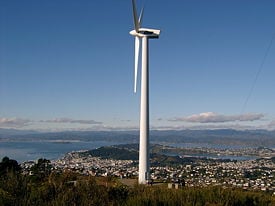
Because of its location in the roaring forties latitudes and its exposure to omnipresent winds coming through Cook Strait, the city is known to Kiwis as "Windy Wellington." Wellington average wind speed is 13.7 miles per hour (22 kilometers per hour) with 22 days per year recording wind speeds in excess of 39 miles per hour (63 kilometers per hour).
Governance
Wellington is New Zealand's political center, housing Parliament and the head offices of all government ministries and departments, plus the bulk of the foreign diplomatic missions based in New Zealand. Wellington is also the seat of regional and local governments.
Federal
New Zealand is a parliamentary democracy and a constitutional monarchy. The only body which can make laws is the House of Representatives commonly called Parliament (120 seats; 69 members elected by popular vote in single-member constituencies including 7 Maori constituencies, and 51 proportional seats chosen from party lists serving three-year terms.[10] The House of Representatives has the power to pass laws and approve the raising and spending of money by the government. The most powerful political body is cabinet made up of ministers of the Crown and chaired by the prime minister. The speaker is the presiding officer of the House of Representatives and is elected by the House. The Executive Council, presided over by the governor general, no longer makes policy decisions, but has formal functions and makes statutory regulations (under powers delegated by Parliament).[11]
Regional
The Greater Wellington Regional Council is responsible for developing policies that direct the activities of the greater Wellington area. They are responsible for such matters as emergency management, the environment, and transportation in the greater Wellington area, which also includes other urban areas in addition to Wellington City. The Council is a statutory body made up of 13 regional councilors, representing six constituencies. Representation in each constituency is determined by population (90 per cent), land area (5 per cent) and land's capital value (5 per cent). Elections are held every three years and all persons 18 years and over are eligible to vote.[12]
Local
The Wellington City Council (WCC) is responsible for determining local legislation and defining the overall vision for the city. The WCC is an elected council made up of a Mayor and fourteen Councilors. The Mayor and Councilors appoint a Chief Executive Officer (CEO) to lead the Council’s administrative organization and to manage Council operations. The CEO has statutory powers granted by the Local Government Act and is responsible for advising the Mayor and Councilors on policy matters and ensuring policies adopted by the Council are correctly implemented.[13]
Economy
Wellington ranks as one of New Zealand’s chief seaports and serves both domestic and international shipping. The port of Wellington handles millions of tons of cargo annually importing petroleum products, motor vehicles, minerals and exporting meats, wood products, dairy products, wool, and fruit. Cruise ships also use the port.
Wellington's economy is primarily service-based, with an emphasis on finance, business services, and government. Many national government departments have their head offices in Wellington and many of New Zealand’s banks and insurance companies have their headquarters in the city.
Wellington has a growing film industry and is a regional health and education center. Tourism is also an important part of the Wellington economy. Manufacturing in the city itself has declined since the late 1980s, however the region still has a printing industry and factories in the Wellington area manufacture chemicals, plastics, clothing, electrical machinery, processed foods, and other products.[14]
Demographics
The population of Wellington is 179,466 according to the 2006 census, while the Wellington Region has a population of 448,959.[15] The ethnic make-up of Wellington's population was European 70.1 percent, Asian 13.2 percent, Maori 7.7 percent, Pacific peoples 5.2 percent, and Others 12.7 percent - note: New Zealand's census allows respondents to identify themselves with more than one ethnicity, so these figures total more than 100 percent.[15]Nearly 23 percent of Wellington's population were born overseas with England the most common foreign birthplace.[16]
Wellington has the highest average income of a main urban area in New Zealand and the highest percentage of people with tertiary qualifications.[17]
Education
Victoria University of Wellington, Wellington's oldest university, has its main campus in the hill suburb of Kelburn overlooking the center of the city. It also has two downtown campuses, and a campus in the western suburb of Karori. It was established as a constituent college of the University of New Zealand.
The senate of the University of New Zealand was located in Wellington until its dissolution in 1961.
There is also a branch of Massey University in Wellington, taking over the former Wellington Polytechnic. The campus is based at the former national museum (the Dominion Museum), which has been replaced by the Te Papa ("Our Place") museum. The University of Otago also has a Wellington connection, as the Wellington School of Medicine and Health Sciences is a department of that university.
Wellington Institute of Technology caters to Wellington and neighboring Petone and the Hutt Valley. It is one of the largest polytechnic schools in the region and was established in 1904.
Numerous primary and secondary educational institutions are located throughout the city, see List of schools in Wellington, New Zealand.
Culture
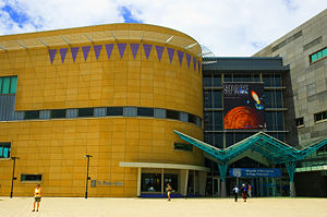
The city's new arts center, Toi Poneke, serves as a nexus of creative projects, collaborations, and multi-disciplinary production. Wellington is home to Te Papa Tongarewa (the Museum of New Zealand), the Museum of Wellington City and Sea, the Katherine Mansfield Birthplace Museum, Colonial Cottage, the New Zealand Cricket Museum, the Cable Car Museum, Old St. Paul's Cathedral, and the Law School (largest wooden building in the southern hemisphere) and the Wellington City Art Gallery.
As the culture capital of New Zealand, Wellington is home to the Royal New Zealand Ballet, the New Zealand Symphony Orchestra, the National Opera and the National dance and drama schools. Wellington also hosts three professional theaters offering Pacific Island, New Zealand and international productions.
Wellington is home to many of New Zealand's Heritage organizations including the National Archives, the National Art Gallery, the National Library, the Museum of New Zealand Te Papa Tongarewa and the National War Memorial.
Financial institutions such as the New Zealand Stock Exchange and the Reserve Bank are located in Wellington as are the National Headquarters of the High Court and the National Cricket Museum.
Wellington's cafe culture is extremely strong. The city has more cafes per capita than New York.
Architecture
Wellington has many notable buildings including the Government Building, on Lambton Quay, which is one of the largest wooden buildings in the world. This colonial-style, four-story structure was built in 1876 and designed to look as though it were made of stone. The Wellington Cathedral of St. Paul is one of New Zealand’s most beautiful churches. The Beehive, probably Wellington’s most famous modern building, houses the executive offices of the national Parliament. This cylindrical structure, completed in 1981, was designed by the British architect Sir Basil Spence.[18]
Religion
As in the rest of the country, more than half (58.4 percent) of Wellingtonians are nominally Christian, and 30.4 percent profess no religion|religious affiliation. In addition to the Christian figures are several Maori Christian denominations including Ratana and Ringatü, accounting for an additional 1.2 percent of the population. The main Christian denominations are Roman Catholic, Anglican (both with 16.9 percent of the population) with 10.2 percent professing Presbyterian, Congregational or Reformed faiths. Other immigrant cultures have added to the religious diversity of the city, adding faiths such as Buddhism, Hinduism, and Islam to Wellington's religious landscape. There is also a small, long-established Jewish community.[19]
Although the role of religion in Wellington life has waned dramatically recently, the city has several important ecclesiastical buildings. These include several synagogues, mosques, temples and other religious buildings and Old St Paul’s Cathedral, a wooden Gothic-revival structure built in 1865, and Futuna Chapel, a modernist style structure designed by Māori architect John Scott.[20]
Festivals
Wellington has become home to a myriad of high-profile events and cultural celebrations, including a biennial International Festival of the Arts, annual International Jazz Festival, and major events such as Cuba Street Carnival, the New Zealand Fringe Festival, the Summer City, the New Zealand Affordable Art Show, numerous film festivals, and the World of Wearable Art.
Sport
Sport is a very important part of all New Zealander’s lives and especially for Wellingtonians.
Wellington’s regular high winds create ideal conditions for sailing and windsurfing, especially on Porirua and Wellington harbors. Wellington’s first cricket club was formed in 1841, and the Basin Reserve, regularly hosts both first-class and international games. Soccer is popular in Wellington with the region represented at the interprovincial level by Team Wellington, and the Wellington Phoenix soccer team representing New Zealand in the Australian A-league.[21] The two main sports grounds in Wellington are Westpac Stadium, one of New Zealand's chief rugby union football grounds, and the Basin Reserve, one of New Zealand’s finest cricket grounds.
Wellington also supports several franchised or local teams that compete in international or inter-provincial competitions. These teams include:
- The Hurricanes (formerly known as the 'Wellington Hurricanes'), that competes in rugby union’s Super 14 competition between teams from New Zealand (5), South Africa (5), and Australia (4).
- The Wellington Firebirds, that compete in New Zealand’s national cricket competitions.
- The Wellington Phoenix, competing in the Australian and New Zealand A-League Soccer competition.
- A netball team playing in the new Australian and New Zealand Netball League.
- The Wellington Lions, competing in the Air New Zealand Cup (formerly NPC) rugby competition.
- The Wellington Orcas, competing in rugby league's Bartercard Cup.
- The Capital Shakers netball team competing in The National Bank Cup.
- The Wellington Saints basketball team competing in New Zealand's National Basketball League.
Sister city relationships
Sister cities
 Beijing, People's Republic of China
 Xiamen, Fujian, People's Republic of China
.svg/22px-Flag_of_Japan_(bordered).svg.png) Sakai, Osaka, Japan
Sakai, Osaka, Japan
Historical sister cities
 Harrogate, England, United Kingdom
 Hania, Crete, Greece
Friendly sister city
Notes
- ↑ About Wellington – Facts & Figures. Wellington City Council. Retrieved June 16, 2012.
- ↑ Wellington City Council Annual Plan 2007–2008. Retrieved June 16, 2012.
- ↑ Statistics New Zealand, Subnational population estimates tables. Retrieved June 16, 2012.
- ↑ 4.0 4.1 4.2 4.3 Greater Wellington Regional Council Maori history of the Greater Wellington region.Retrieved November 14, 2007 Cite error: Invalid
<ref>tag; name "GW" defined multiple times with different content - ↑ 5.0 5.1 5.2 5.3 Chris Maclean. Te Ara - the Encyclopedia of New Zealand Wellington Retrieved November 18, 2007.
- ↑ 6.0 6.1 World Facts Wellington. Retrieved November 18, 2007.
- ↑ [1].endangeredspecies handbook. Retrieved July 6, 2008.
- ↑ Eileen McSaveney. Te Ara - the Encyclopedia of New Zealand Active faults. Retrieved November 16, 2007
- ↑ 9.0 9.1 Christchurch City Council New Zealand Disasters. Retrieved November 14, 2007.
- ↑ CIA World Fact Book New Zealand.
- ↑ John Wilson. Te Ara - the Encyclopedia of New Zealand Government and nation. Retrieved November 16, 2007.
- ↑ Greater Wellington Regional Council Council committees Retrieved November 16, 2007.
- ↑ Wellington City Council Structure.Retrieved November 16, 2007.
- ↑ Encyclopedia Britannica Wellington.
- ↑ 15.0 15.1 Wellington City Council Facts and Figures. Retrieved November 14, 2007
- ↑ Statistics New Zealand Wellington City. Retrieved November 14, 2007
- ↑ Statistics New Zealand Education Retrieved November 14, 2007
- ↑ World Book Online Reference Center Wellington. Retrieved November 15, 2007
- ↑ Statistics New Zealand 2001 Census Religious Affiliation. Retrieved November 16, 2007.
- ↑ Chris Maclean. Wellington TeAra - Encyclopedia of New Zealand. Retrieved December 21, 2007.
- ↑ Maclean. Wellington. Te Ara - the Encyclopedia of New Zealand. Retrieved November 16, 2007.
ReferencesISBN links support NWE through referral fees
- Beckner, Chrisanne. 1995. 100 great cities of world history. San Francisco, CA: Bluewood Books. ISBN 9780912517148
- Fulton Hogan Holdings, and Transit New Zealand. 2007. Wellington inner city bypass project heritage buildings. Wellington, N.Z.: Fulton Hogan.
- Watters, R. F. 1965. Land and society in New Zealand; essays in historical geography. Wellington: A.H. & A.W. Reed.
External links
All links retrieved May 3, 2023.
- Greater Wellington Regional Council
- Official NZ Tourism website for Wellington
- Wellington City Council
Credits
New World Encyclopedia writers and editors rewrote and completed the Wikipedia article in accordance with New World Encyclopedia standards. This article abides by terms of the Creative Commons CC-by-sa 3.0 License (CC-by-sa), which may be used and disseminated with proper attribution. Credit is due under the terms of this license that can reference both the New World Encyclopedia contributors and the selfless volunteer contributors of the Wikimedia Foundation. To cite this article click here for a list of acceptable citing formats.The history of earlier contributions by wikipedians is accessible to researchers here:
The history of this article since it was imported to New World Encyclopedia:
Note: Some restrictions may apply to use of individual images which are separately licensed.
